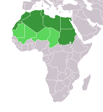
Fichier:Africa-countries-northern.png
Apparence
Africa-countries-northern.png (360 × 392 pixels, taille du fichier : 10 kio, type MIME : image/png)
Historique du fichier
Cliquer sur une date et heure pour voir le fichier tel qu'il était à ce moment-là.
| Date et heure | Vignette | Dimensions | Utilisateur | Commentaire | |
|---|---|---|---|---|---|
| actuel | 17 Marisikalo 2018 à 15:22 |  | 360 × 392 (10 kio) | Maphobbyist | Montenegro border |
| 31 Marisikalo 2016 à 21:00 |  | 360 × 392 (10 kio) | Fry1989 | Reverted to version as of 16:12, 13 January 2014 (UTC) | |
| 7 Nowanburukalo 2015 à 09:37 |  | 360 × 392 (10 kio) | Hpyounes | correction | |
| 13 Zanwuyekalo 2014 à 16:12 |  | 360 × 392 (10 kio) | VVVF | See http://unstats.un.org/unsd/methods/m49/m49regin.htm | |
| 13 Zanwuyekalo 2014 à 15:59 |  | 360 × 392 (13 kio) | VVVF | Reverted to version as of 20:15, 9 July 2011. See http://unstats.un.org/unsd/methods/m49/m49regin.htm | |
| 20 Zuluyekalo 2011 à 12:47 |  | 360 × 392 (7 kio) | Kahusi | See http://unstats.un.org/unsd/methods/m49/m49regin.htm | |
| 9 Zuluyekalo 2011 à 20:15 |  | 360 × 392 (13 kio) | Maphobbyist | South Sudan has become independent on July 9, 2011. Sudan and South Sudan are shown with the new international border between them. | |
| 5 Mɛkalo 2006 à 11:13 |  | 360 × 392 (4 kio) | Hautala | optimized with png | |
| 20 Awirilikalo 2005 à 16:30 |  | 360 × 392 (14 kio) | Yonghokim | map of countries in Northern Africa. from en:Image:Africa-countries-northern.png {{GFDL}} |
Utilisation du fichier
Aucune page n’utilise ce fichier.
Usage global du fichier
Les autres wikis suivants utilisent ce fichier :
- Utilisation sur ce.wikipedia.org
- Utilisation sur es.wikipedia.org
- Utilisation sur fr.wikipedia.org
- Utilisation sur he.wikipedia.org
- Utilisation sur os.wikipedia.org
- Utilisation sur ru.wikipedia.org
- Utilisation sur sc.wikipedia.org
- Utilisation sur smn.wikipedia.org
- Myenster:Afrik staatah
- Myenster:Navbox
- Algeria
- Angola
- Benin
- Botswana
- Burkina Faso
- Burundi
- Djibouti
- Egypt
- Elefanttähtiriddo
- Eritrea
- Eswatini
- Etiopia
- Gabon
- Gambia
- Ghana
- Guinea
- Guinea-Bissau
- Kamerun
- Kap Verde
- Kenia
- Komoreh
- Kongo demokraatlâš täsiväldi
- Kongo täsiväldi
- Koskâ-Afrik täsiväldi
- Lesotho
- Liberia
- Libya
- Maadâ-Afrik
- Maadâ-Sudan
- Madagaskar
- Malawi
- Mali
- Marokko
- Mauritania
- Mauritius
Voir davantage sur l’utilisation globale de ce fichier.


